![]()

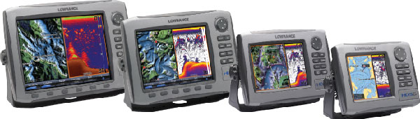
"Lowrance HDS Fish Finder, Thermocline & Structure Superstar Meters"
120 channels of SIRIUS® Satellite Radio
Built-in Lowrance Fishing Hot Spots®
Brighter Displays, 1-Button Access To Many Favorite Features
High Definition Broadband Fishing
Expandability at No Extra Cost
Sirius Inland Weather Service Package
Now Adds Inland Choice to Standard Offshore Coverage
NEW Insight USA™ - A Charting Revolution in Detail and Resolution
Insight, with over 100,000 bodies of water and nearly 5,000 enhanced U.S. lakes
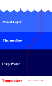
The thermocline is the transition layer between the mixed layer at the surface and the deep water layer. The definitions of these layers are based on temperature.
The mixed layer is near the surface where the temperature is roughly that of surface water. In the thermocline, the temperature decreases rapidly from the mixed layer temperature to the much colder deep water temperature.
The mixed layer and the deep water layer are relatively uniform in temperature, while the thermocline represents the transition zone between the two.
Locating
feeding fish is one of the most important skills a fisherman can develop. You
can mark fish on your fish finder and not entice them to strike your lure if
they are not in their "feeding zone"! Most species of fish have a preferred
temperature of water that they will actively feed in. Find this area of
temperature with fish present and you will greatly increase your chances of
catching fish. Remember, fish are cold blooded. In water too cold, fish will
be dormant, sluggish and will not feed. In water too warm, they will be
seeking a more comfortable environment. So, an understanding of how different
temperatures of water break up will help.
Here are two
main ways temperatures of water will break up:
On inland lakes, water temperatures tend to settle into
horizontal layers of warm water and cold water that are separated by a
moderating layer known as the "thermocline". The thermocline will be the most
active "feeding zone". On larger bodies of water like the oceans and Great
Lakes, masses of water temperature are much larger and in a constant state of
change. The location of these large masses of temperature are highly affected
by the changes in weather conditions. These large masses of warm and cold
water also have a moderating layer that is known as a "temperature break".
Because of the
constant shifting of the warm and cold masses temperature breaks often appear
as a vertical layer. The area of, and immediately around, the temperature
break is the most active "feeding zone".
If you're a
bass fisherman, the thermocline is something that's very important you must
know and understand to be successful.
Simply put, the thermocline is a thin layer of
water in a lake which is sandwiched between the upper layer of water (the
epilimnion) and the lower, colder layer of water (hypolimnion). During the
summer months, surface water is heated by the sun and the surface temp could
be 80 degrees or more. This floats over a layer of colder more denser water
called the hypolimnion. Now, between these 2 layers you have a thin layer in
which the water temp drops fair substantially. This will be the thermocline.
The temp at this level may be high 60's and up in about the middle of spring.
Let's relate this to Lake Fork, Texas. Normally the thermocline starts to set
up in May. Fishermen have been able to enjoy catching spawning bass in depths
of 2'-12' during the spawn. Bass have needed the warmer water temps to spawn
(lower 60's and up). Moving on into the end of May, most bass have spawned at
Lake Fork. This is a time of transition for the bass. As a fisherman, you are
in a post spawn mode. Crankbaits, lizards, jigs and Carolina Rigs, to name a
few have worked well for spawning bass and should still continue to produce
through the summer. As we move into the end of May and into June you can look
for the post spawn to set in. This is generally the time the Thermocline will
start to set up. When the water temps reach about 73 degrees, you can plan on
predictable fishing. Plastic worms work well, Crankbaits, spoons and jigs to
name a few. Usually water depths between 12' to approximately 22' are the
depths of choice. This is the thermocline.
In full-blown summer you will have 3 distinct water temperature changes (at
these approximate depths), 0 to 12', 12' to 22', and 22' to 45'. The
temperature may drop by 10 degrees at each depth. Many of you have probably
heard of a lake "turning over" and this is exactly what it does. During late
Autumn, (usually in October on Lake Fork) the cold winds blow as the fronts
start coming through. This in turn drops the waters surface temperature. As it
cools this surface water
will sink to the bottom of the lake. So when cooler weather arrives the layer
that was the warmest (the surface layer) displaces the lower level and the
lake turns over. This movement which occurs every year allows the bottom layer
to be exposed to the air allowing it to be used by living organisms. In
shallow lakes with an average depth of 15 feet usually no thermocline will
develop. Mother nature keeps all this in check. In such cases as very shallow
lakes you may find heavy
cover to screen out some of the suns penetrating rays.
October is a month of water temperature changes, once again, for Lake Fork.
Depending on our weather you will find water temps becoming more uniform from
the surface to about 25' in most areas of the lake. The temps may vary from 69
degrees (surface temp), to 66 degrees down to the 22' mark, give or take a few
feet. Fall fishing patterns have set in and you can count on nice numbers of
fish with predictable patterns. Is the hypolimnion void of oxygen? At certain
times of
the year this may true but there are also certain times when it has more
oxygen than the other layers of water. As you already know the turnover on
Lake Fork usually occurs in October. The water begins to cool. The shallow
coves are among the first to cool and the bass will begin to relate to shallow
structure, this is why fall fishing is fantastic at Lake Fork. Generally
speaking the thermocline averages 7 to 10 feet thick and is usually found at
22' of water. The bass will be
caught in the upper regions of the thermocline (early October), but usually
the best fishing occurs just above where the thermocline starts.
The main thing to remember is when stratification is evident the bass will be
found in greater concentrations within the thermocline. Why is this? Two
reasons. First the upper layer has too much light penetration to be
comfortable for the bass and the hypolimnion is usually void of oxygen. This
leaves the thermocline where the light is just right and the oxygen is
comfortable for the bass. Remember bass can see ultraviolet rays and do not
have eyelids, their pupils do not
adjust as humans do. Also remember sunlight will diffuse differently depending
on the time of day. Early morning and late afternoon the suns rays will be at
more of an angle and not as intense. Wind will also affect the suns
penetration into the water, as will the clarity of the water. Can you catch
bass in the hypolimnion? Why do anglers catch bass in 40 feet or deeper water?
During the late winter there is usually no stratification on Lake Fork or most
other lakes. As a result the water will undergo a temporary oxygenation
process. Strong winds, feeder streams feed the lake with spring rains and
plant growth begins. So under normal conditions the deeper end of a water body
will be quite saturated with oxygen. Since the lower layer is much colder than
the surface (averages 10 to 25 degrees difference) the deeper portions can
retain the oxygen molecules sent its way during the pre-stratification. Why
does the hypolimnion lose it's oxygen? The thermocline
and the upper layer of water are continually replenishing their oxygen supply
and the hypolimnion gradually loses it for several reasons. Probably the most
important reasons are is that there is very little or no plant life beyond the
30 foot level. Unless the water is gin clear the suns rays cannot penetrate
this far into Lake Fork enough to grow any vegetation.
The bottom 2 to 10 feet of a lake will also be where everything settles to
decay thus eating up the oxygen. Fishermen will find Lake Fork usually has no
thermocline until late spring or early summer and its this time you must
understand what the thermocline is and what role it plays on fishing. Lake
Fork and most all lakes will turnover in the fall. When this happens you can
usually smell something that resembles the smell of rotten eggs and many times
you will see particles of
decaying matter in the water, this is the tale-tell sign that the lake has
turned over. Some years, depending on the weather we have, the turnover will
be more abrupt than others. Back in October 1994 Lake Fork experienced quite
an abrupt turnover. Millions of shad were seen either dying or dead on the
surface, and many fishermen reported the very strong smell of rotten eggs for
a week or so. Estimates of the shad die off that year was over 12 million.
Luckily though shad reproduce extremely fast and no noticeable decline in
fishing occurred due to this turn over.
Take a look at the background on this web page. Once the water starts setting
up in layers usually in late spring or early summer depending on how much warm
weather we have, the layers will look like the layers on this page. You will
find some fish in the top layer, the bottom part of the top layer and at
varying depths within what is called the thermocline. Most times you will be
wasting your time if you fish any deeper than the thermocline. Many times your
electronics can
pick up these varying layers of water. On quality, high end electronics you'll
see a washed out line. This will represent where there are drastic differences
in the water temperatures.
"Lowrance HDS Fish Finder, Thermocline & Structure Superstar Meters"
120 channels of SIRIUS® Satellite Radio
Built-in Lowrance Fishing Hot Spots®
Brighter Displays, 1-Button Access To Many Favorite Features
High Definition Broadband Fishing
Expandability at No Extra Cost
Sirius Inland Weather Service Package
Now Adds Inland Choice to Standard Offshore Coverage
NEW Insight USA™ - A Charting Revolution in Detail and Resolution
Insight, with over 100,000 bodies of water and nearly 5,000 enhanced U.S. lakes
Lowrance HDS Fish Finder Links Below
LOWRANCE Marine High-Definition Meters
The thermocline (sometimes metalimnion) is a thin but distinct layer in a large body of fluid (e.g. water, such as an ocean or lake, or air, such as an atmosphere), in which temperature changes more rapidly with depth than it does in the layers above or below. In the ocean, the thermocline may be thought of as an invisible blanket which separates the upper mixed layer from the calm deep water below. Depending largely on season, latitude and turbulent mixing by wind, thermoclines may be a semi-permanent feature of the body of water in which they occur, or they may form temporarily in response to phenomena such as the radiative heating/cooling of surface water during the day/night. Factors that affect the depth and thickness of a thermocline include seasonal weather variations, latitude, and local environmental conditions, such as tides and currents.
Depth at which
the rate of decrease of temperature with increase of depth is the largest. In
general the sea water temperature decreases from the surface to the deepest
levels, except in high latitudes where the configuration can be more complex.
There exists in most ocean areas (apart from polar and sub-polar oceans) a
zone where the rate of decrease of temperature is much larger compared with
that above and below, hence the definition. Depending on the geographical
location, the thermocline depth ranges from about 50m to 1000m. A simplified
view is to consider the thermocline as the separation zone between the
mixed-layer above, much influenced by atmospheric fluxes, and the deep ocean.
In the tropics, the thermocline can be quite shallow on average, as in the
eastern Pacific (50m), or deeper as in the western part (160-200m). In
extra-tropical regions a permanent (or main) thermocline is found between 200m
and 1000m. However the thermocline depth varies seasonally, especially in the
mid-latitude regions where a secondary and much shallower thermocline (above
50m) occurs in summer. In high latitudes, a thermocline may appear only
seasonally. Thermocline can also vary from one year to the next, as in the
tropical Pacific where thermocline vertical displacements play a fundamental
role during ENSO. As the pycnocline, the thermocline is a prominent feature of
the ocean which conditions many physical, chemical and biological processes
occurring in the oceanic upper layers. In many situations, the thermocline can
be identified with the pycnocline when the vertical contrasts of
salinity are small.